| John Bidwell |
Trail Guide |
Historical Background |
Aug 10 |
11 |
12 |
13 |
14 |
15 |
16 |
17 |
18 |
19-20 |
21-22 |
23 |
| 24-25 | 26 | Aug 27 - Sep 4 | 5 | 6 | 7-8 | 9 | 10 | 11 | 12 | 13 | 14 | 15 | All Photos |
| 24-25 | 26 | Aug 27 - Sep 4 | 5 | 6 | 7-8 | 9 | 10 | 11 | 12 | 13 | 14 | 15 | All Photos |
Corinne to Bidwell Pass
August 21-22, 1841
Before traveling westward to Kelton, Lucin, Donner Spring, and Wendover, be prepared. After twenty-five miles of paved road, you will be traveling on gravel roads into desolate desert country. Food, water, and gasoline are NOT available in Park Valley, seventy-eight miles from Corinne, but are available in Wendover, eighty-five miles from Park Valley.
 |
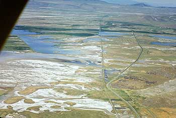 |
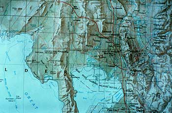
| This a relief map showing the Great Salt Lake and the area the Bidwell Party had to traverse going west above the lake. | This aerial view is facing west of Corinne showing the wet areas above the lake and the 1869 railroad bed going straight west in the center of the photo. Highway SR 38 is the road curving to the right on the right hand side of the photo. The trail had to follow close to that of SR 38. |
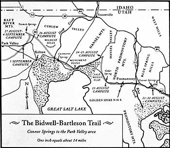 |
| This map shows the approximate location of the Bidwell Trail which is the light wider gray line in the center of the map. |
 |
|
This is Conner Springs where the Bidwell Party camped on Friday the 20th of August. Bidwell wrote: "Marched off in a northwest direction, and intersected our trail of Thursday last, having made a complete triangle in the plain. At this intersection of the trails, we left a paper elevated by a pole, that the men returning from Fort Hall might shun the tedious rounds we had taken. Found grass and water which answered our purpose very well, though both were salt. Distance, ten miles."
Sunday, 22nd: "This morning a man (Mr. Bralaski) returned from the Fort, and said the reason why he came alone was, the other man had left him, because he was unable to keep up with them, he having a park-horse laden with provision. He had seen the paper at the intersection of the trails and was guided by it to the camp; the others were undoubtedly going the rounds of the triangle. Sure enough, they came up in the afternoon, having gone to the river and back..." |
Travel north to the junction with SR 13 (State Road). Turn left onto SR 13, then turn left at the Y onto SR 83. Travel west to 6800 west. Turn right and turn around by the rail post marker which reads:
BIDWELL /BARTLESON TRAIL
TRIANGLE IN THE PLAIN
TRIANGLE IN THE PLAIN
First Overland Emigrant Party
"Marched off in a N.W. direction, and intersected our trail of Thursday last, having made a complete triangle in the plain."
John Bidwell, August 21, 1841
2000 Utah Crossroads Chapter - OCTA BBU-4
When finished turn right on SR 83 and travel west to the JUNCTION with SR 102.
Turn right and travel 1.7 miles to the northeast until you come to a house on your right. This is Connor Springs, the 21-22 AUGUST CAMPSITE. James John wrote: "21st Travelled about 12 miles and came to a large salt springs where we camped. 22nd. Stayed in camp on account of our oxen straying. We found them towards evening. The men who went to Fort Hall, 7 in number, returned today. They obtained some provisions but could get no pilot." The rail post marker reads:
BIDWELL /BARTLESON TRAIL - CONNOR SPRINGS
First Overland Emigrant Party
"21st. Travelled about 12 miles and came to a large Salt Spring where we camped. ...22nd. Stayed in camp on account of Oxen straying... The men who went to Fort Hall... returned today."
James John, August 21, 22, 1841
2000 Utah Crossroads Chapter - OCTA BBU-5
| August 19-20, 1841 |
|---|