| John Bidwell |
Trail Guide |
Historical Background |
Aug 10 |
11 |
12 |
13 |
14 |
15 |
16 |
17 |
18 |
19-20 |
21-22 |
23 |
| 24-25 | 26 | Aug 27 - Sep 4 | 5 | 6 | 7-8 | 9 | 10 | 11 | 12 | 13 | 14 | 15 | All Photos |
| 24-25 | 26 | Aug 27 - Sep 4 | 5 | 6 | 7-8 | 9 | 10 | 11 | 12 | 13 | 14 | 15 | All Photos |
August 23, 1841
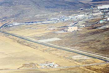
Return to SR 83. Travel west on SR 83 to the JUNCTION (3.5 miles) with a road on the left. This is Lampo Junction, and just north of here is Thiokol's Wasatch Division, an industrial facility devoted to research, development, and manufacture of solid-propellant rocket motors. Occupying more than one hundred brightly colored buildings, the Thiokol plant is the largest of its kind in the world. Interestingly, Thiokol's plant, whose rocket motors are used to launch NASA's space shuttle, is within sight of another transportation landmark--the completion of the nation's first transcontinental railroad.
 |
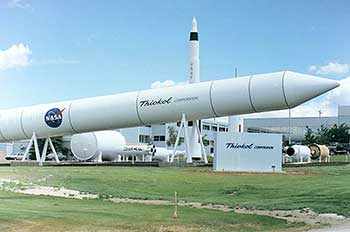 |
| This photo is of the Thiokols Wasatch Division that manufactures solid-propellant rocket motors. The junction of the roads in the lower right hand corner of the photo is called Lampo Junction and the road at the bottom goes to the Golden Spike National Historic Site and would be close to the Bidwell Trail. | This is a Thiokols display of all their rockets and rocket motors in front of their main building. Visitors welcome. |
This is the place of the firsts: First overland emigrant party, first white woman to cross Utah, first white child, first Railroad, first solid fuel rocket motor used to propell man to the moon, and first air bag manufactured by Thiokol for cars.
Turn left at Lampo Junction and travel west 6.7 miles on the paved road. Take the right-hand fork up the hill past railroad cuts and fills to where the pavement turns left. The road to the left goes south 1.2 miles to GOLDEN SPIKE NATIONAL HISTORIC SITE (7.9 miles). Golden Spike National Historic Site marks Promontory Summit, the place where the Union Pacific and Central Pacific railroads met on 10 May 1869, to form the nation's first transcontinental railroad.
 |
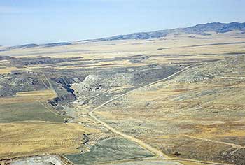 |
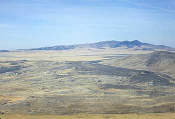
| This photo is looking northwest. The 1869 railroad grade is in the center of the photo. The pass that the emigrants took is on the left edge & center of the photo. | This photo is of a canyon or "declivity" as the emigrants called it. This could be where the emigrants saw a sage brush fence to trap rabbits. We were told that there are many Indian pictographs in this canyon. |
The culmination of the nation's dream to unite the east and west coasts brought major changes to the country. The new railroad provided the first practical means of round-trip travel. New opportunities for commerce brought buffalo hunters, who depleted the great bison herds that roamed the plains; it was not long before the bison, and the Plains Indians who hunted them, virtually disappeared. The railroad also advanced the settlement of Nebraska, Wyoming, Colorado, Utah, Nevada, and California, as immigrants in search of fertile farmland rode the rails west by the thousand
A visitor's center straddles the summit's viewing area where two replica locomotives--Jupiter and Engine 119--face each other as they did at the 1869 joining of the rails. Each year on 10 May, the joining of the rails ceremony is reenacted for the public. Travel back 1.2 miles to the bend in the pavement.
Travel west on the gravel road to the summit and a rail post on the right. The marker reads:
BIDWELL /BARTLESON TRAIL - SALT LAKE
First Overland Emigrant Party
"At evening we arrived in full view of the Salt Lake; water was very scarce. Cedar grows here both on the hills and in the valleys. Distance 20 miles."
John Bidwell, August 23, 1841
2000 Utah Crossroads Chapter - OCTA BBU-6
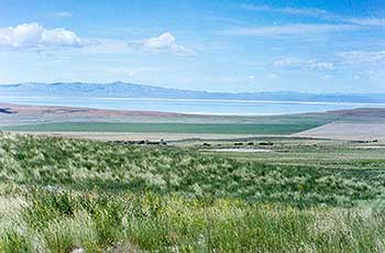
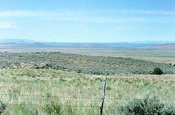
Continue down to CEDAR SPRINGS (4.8 miles), on the left. From here is seen the vista of Great Salt Lake that Bidwell saw from their 23 AUGUST CAMPSITE. John Bidwell described the view:
"At evening we arrived in full view of the Salt Lake, water was very scarce. Cedar grows here both on the hills and in the valleys, distance 20 miles." James John also described the view: "Camped at night at a small spring where we did not get half enough water for the animals. We are near the Salt Lake and frequently travelled over plains covered with salt which is good for use."
 |
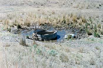 |
| This is the first real good look that the Bidwell party had of the Salt Lake. Bidwell wrote: "Monday, 23. Started, bearing our course west, in order to pass the Salt Lake, passed many salt plains and springs in the forenoon. The day was hot. The hills and land bordering on the plains were covered with wild sage. In passing the declivity of a hill, we observed this sage had been plucked up and arranged in long winrows, extending near a mile in length. It had been done by the Indians, but for what purpose we could not imagine, unless it was to decoy game. At evening, we arrived in full view of the Salt Lake. Water was very scarce. Cedar grows here, both on the hills and in the valleys. Distance, twenty miles." | This is Cedar Springs. As you can see there is very little water as noted by James John: "23rd. Travelled about 20 miles. Passed a number of Salt Springs. Some difficulty in finding fresh water. Camped at night at a small spring where we did not get half enough water for the animals. We were near the Salt Lake and frequently travelled over plains covered with salts which is good for use." "24th. This morning we were detained by the Oxen straying. Did not find them till about 10 oclock...." |
 |
 |
| This view of the lake is toward what is called the threshold, the opening in the mountains to the flat mud plains and west desert. | This is an aerial view of the small Cedar Springs the round tank that can be seen in the lower right of the photo. |
With the exception of the Dead Sea, Great Salt Lake is the saltiest body of water on Earth. Occupying a large part of northern Utah, the lake is seventy-two miles long and thirty miles wide, but only ten to thirty feet deep. The only crossing over the lake is the 102-mile Southern Pacific Railroad cutoff between Ogden and Lucin.
Centuries ago, the northwestern quarter of Utah was covered by Lake Bonneville, a great fresh-water lake ten times the size of Great Salt Lake. Covering more than twenty-thousand square miles in Utah, Nevada, and Idaho, the lake was one thousand feet deep where Great Salt Lake now lies and nine hundred feet deep at the site of Salt Lake City. Lake Bonneville left a distinct shoreline that is still visible. The lake broke through its barrier at the outlet, Red Rock Pass, north of the Battle Creek campsite in Idaho, and with a change in climate the huge lake fell below its lowest outlet and shrank to today's Great Salt Lake. Depending on the water level, Great Salt Lake's salinity varies from 15 to 25 percent, at least six times saltier than the ocean.
A few of the islands in Great Salt Lake are inhabited by wildlife. The largest island, Antelope Island, named by John C. Fremont in 1845, provides a refuge for about five hundred American Bison. Antelope and elk have been re-introduced recently to Antelope Island, which is now a state park.
Great Salt Lake rose over twelve feet between 1967 to 1983, covering I-80, Saltair beaches, the roads to Antelope Island, and wildlife refuges. Road grades were raised, dikes built, and pumps installed to pump the high water into the Great Salt Lake Desert. The lake has since receded.
The Great Salt Lake Desert, west of Great Salt Lake, is part of the bed of ancient Lake Bonneville and is composed of clay washed into the huge lake thousands of years ago. At the Bonneville Salt Flats, a low place in this basin located east of Wendover, Utah, salt has been deposited over time. The water from the pumping project covered approximately eight hundred square miles of the Great Salt Lake Desert with salt water, which has since evaporated, leaving a salt crust averaging about six inches thick and covering the Donner-Reed trail.
| August 21-22, 1841 |
|---|