| John Bidwell |
Trail Guide |
Historical Background |
Aug 10 |
11 |
12 |
13 |
14 |
15 |
16 |
17 |
18 |
19-20 |
21-22 |
23 |
| 24-25 | 26 | Aug 27 - Sep 4 | 5 | 6 | 7-8 | 9 | 10 | 11 | 12 | 13 | 14 | 15 | All Photos |
| 24-25 | 26 | Aug 27 - Sep 4 | 5 | 6 | 7-8 | 9 | 10 | 11 | 12 | 13 | 14 | 15 | All Photos |
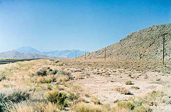 |
| This is the approximate area where the Bidwell Party camped on September 10th, with out water by a rock mountain. This site is about one half mile north from where the Central Pacific built their railroad grade. James John wrote on September 10th: "This morning the Indians were dismissed and we gave them some powder and lead balls which appeared to satisfy them for their service. We travelled about 14 miles today and then camped near the foot of a mountain with neither water nor grass for our animals." If the party had kept the Indians as guides they would have had a better shorter route to the Humboldt River. |
September 10, 1841
Continue southwest to a HISTORICAL MARKER (3.5 miles), on the left. Travel 7.0 miles until you come to a slight bend in the road. South of this bend one mile is the 10 SEPTEMBER CAMPSITE. James John wrote:
"This morning the Indians were dismissed and we gave them some powder and lead balls which appeared to satisfy them for their service. We travelled about 14 miles today and then camped near the foot of a mountain with neither water nor grass for our animals."
| September 9, 1841 |
|---|