| John Bidwell |
Trail Guide |
Historical Background |
Aug 10 |
11 |
12 |
13 |
14 |
15 |
16 |
17 |
18 |
19-20 |
21-22 |
23 |
| 24-25 | 26 | Aug 27 - Sep 4 | 5 | 6 | 7-8 | 9 | 10 | 11 | 12 | 13 | 14 | 15 | All Photos |
| 24-25 | 26 | Aug 27 - Sep 4 | 5 | 6 | 7-8 | 9 | 10 | 11 | 12 | 13 | 14 | 15 | All Photos |
August 12, 1841
Continue south to the JUNCTION (3.3 miles) with Thatcher road and the 12 AUGUST CAMPSITE. Turn right onto Thatcher road, and travel south past the Thatcher Ward to the JUNCTION (7.3 miles) with Cleveland road. Travel south on Cleveland road to the JUNCTION (6.0 miles) with 13400 North. Turn left and travel east on 13400 North to the JUNCTION (0.8 miles) with SR 34. At this point, you can see the Oneida Narrows to the south. The Oneida Narrows is where the Bear River cuts though the mountains and where, downstream, a dam has been built to form Oneida Narrows Reservoir.
 |
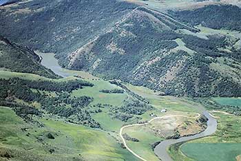 |
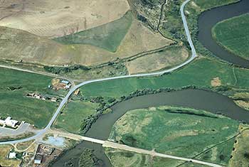
| This photo is at Thatcher, Idaho. The Thatcher LDS meeting house is in the lower left hand side of the photo. The August 12, campsite was off the photo to the right and near the Bear River which runs meandering through the photo. | This photo is at the beginning of the Oneida Narrows which prohibited the travel through the canyon by the Bidwell Party, Indians & Trappers. A dam now backs the water up which you can see in the upper left hand quarter of the photo. A gravel road has now been cut above the reservoir down to the dam and connecting to the road to Preston, Idaho. |
| August 11, 1841 |
|---|